CapitalHagatna (Agana)
LanguagesEnglish, Filipino, Chamorro, various Pacific Island languages, Asian languages
Governmentan unincorporated organized territory of the United States with local self-governance; it operates under a republican structure of territorial government, which includes distinct executive, legislative, and judicial branches
Bamwor Indexes
Guam — Q1 2026
IBEUBamwor Urban Scale Index
26.51%
Rank #54 of 237
View full ranking →
IBCPBamwor Population Concentration Index
70.81%
Rank #32 of 237
View full ranking →
IBDABamwor Settlement Density Index
238.97per 1K km²
Rank #64 of 241
View full ranking →
IBCXBamwor Country Complexity Index
43.25/100
Rank #176 of 234
View full ranking →
IBEEBamwor Economic Stability Index
90.69/100
Rank #51 of 220
View full ranking →
IBDIBamwor Digital Infrastructure Index
83.72/100
Rank #46 of 206
View full ranking →
IBSABamwor Healthcare Index
76.68/100
Rank #49 of 218
View full ranking →
Guam Intelligence Report
Download PDF with 20+ statistics, rankings & proprietary indices
Introduction
Background
Around 1500 B.C., Guam was inhabited by Austronesian peoples who eventually evolved into the indigenous Chamorro. This group experienced influences from subsequent migrations, notably the Micronesians during the first millennium A.D. and island Southeast Asians around 900. The societal structure was hierarchical, with the elite residing along the coastal areas while the lower classes were situated inland. The first European to sight Guam was the Spanish navigator Ferdinand MAGELLAN in 1521, and Spain claimed the territory in 1565, recognizing its strategic role as a refueling station for ships traveling between Mexico and the Philippines. Formal colonization by Spain commenced in 1668. The indigenous Chamorro faced severe oppression from Spain, compounded by the introduction of new diseases and sporadic conflicts, which led to a dramatic decline in their population from over 100,000 to fewer than 5,000 by the 1700s. To address this demographic crisis, Spain attempted to resettle individuals from neighboring islands onto Guam, while also restricting their freedom to leave.
In the early 1800s, Guam emerged as a central location for whalers and traders within the western Pacific. Following the outbreak of the Spanish-American War in 1898, the US Navy took control of Guam, establishing a military administration. Despite numerous appeals from the Chamorro for local governance, the US Navy resisted such efforts. The island was invaded by Japan in 1941, which implemented a harsh regime. During the recapture of Guam by US forces in 1944, the two largest villages were obliterated. After World War II, due to advocacy from local Chamorro leaders, Guam was designated as an unincorporated organized territory of the United States in 1950, with US citizenship being extended to all Chamorro. In a 1982 referendum, over 75% of voters expressed a preference for closer ties with the US instead of independence; however, no alterations to the status were made due to disagreements regarding the future rights of Chamorro self-determination. Currently, the US military occupies approximately 29% of Guam’s territory and maintains a presence of several thousand troops on the island. These military installations are among the most strategically vital US bases in the Pacific and represent the primary source of income and economic stability for the island.
Geography
Area
land
544 sq km
water
0 sq km
total
544 sq km
Climate
characterized by a tropical marine climate; typically warm and humid, influenced by northeast trade winds; experiences a dry season from January to June and a rainy season from July to December; exhibits minimal seasonal temperature fluctuations
Terrain
originating from volcanic activity, encircled by coral reefs; features a relatively flat coralline limestone plateau, which is the primary source of fresh water, alongside steep coastal cliffs and narrow coastal plains to the north, with low hills in the center and mountains to the south
Land use
other
18% (2023 est.)
forest
52.4% (2023 est.)
agricultural land
29.6% (2023 est.)
agricultural land: arable land
arable land: 1.9% (2023 est.)
agricultural land: permanent crops
permanent crops: 13% (2023 est.)
agricultural land: permanent pasture
permanent pasture: 14.8% (2023 est.)
Location
located in Oceania, this island resides in the North Pacific Ocean, approximately three-quarters of the distance from Hawaii to the Philippines
Coastline
125.5 km
Elevation
lowest point
Pacific Ocean 0 m
highest point
Mount Lamlam 406 m
Irrigated land
2 sq km (2012)
Map references
Oceania
Land boundaries
total
0 km
Maritime claims
territorial sea
12 nm
exclusive economic zone
200 nm
Natural hazards
subject to frequent squalls during the rainy season; while typhoons are relatively uncommon, they can be destructive and occur between June and December
Geography - note
the largest and southernmost island within the Mariana Islands archipelago, it is also the largest island in Micronesia, holding a strategically important position in the western North Pacific Ocean
Natural resources
home to aquatic wildlife that bolsters tourism and fishing, which remains largely underdeveloped
Area - comparative
three times larger than Washington, D.C.
Geographic coordinates
13 28 N, 144 47 E
Population distribution
the island does not have any large urban centers; instead, sizable villages (municipalities) house most of the population, with Dededo being the largest among them
People & Society
Languages
English 43.3%, Filipino 24.9%, Chamorro 16%, various Pacific Island languages 9.4%, Asian languages 6.5% (2020 estimate)
Religions
Christianity (mainly Roman Catholic) 94.2%, traditional folk beliefs 1.5%, Buddhism 1.1%, other faiths 1.6%, non-religious 1.7% (2020 estimate)
Sex ratio
at birth
1.07 male(s)/female
0-14 years
1.07 male(s)/female
15-64 years
1.1 male(s)/female
total population
1.06 male(s)/female (2024 est.)
65 years and over
0.88 male(s)/female
Birth rate
17.9 births/1,000 population (2025 est.)
Death rate
6.18 deaths/1,000 population (2025 est.)
Median age
male
29.6 years
total
30.5 years (2025 est.)
female
31.1 years
Population
male
87,345
total
169,532 (2024 est.)
female
82,187
Nationality
noun
Guamanian(s) (US citizens)
adjective
Guamanian
Urbanization
urban population
95.2% of total population (2022)
rate of urbanization
0.84% annual rate of change (2020-25 est.)
Age structure
0-14 years
26.4% (male 23,139/female 21,632)
15-64 years
62.7% (male 55,591/female 50,741)
65 years and over
10.9% (2024 est.) (male 8,615/female 9,814)
Ethnic groups
Native Hawaiian and other Pacific Islander 46.1% (Chamorro 32.8%, Chuukese 6.7%, Palauan 1.4%, Pohnpeian 1.4%, Yapese 1%, other Native Hawaiian and other Pacific Islander 2.8%), Asian 35.5% (Filipino 29.1%, Korean 2.2%, Japanese 1.4%, Chinese (except Taiwanese) 1.3%, other Asian 1.5%), White 6.8%, African descent or African-American 0.9%, Indigenous 0.1%, other 0.6%, mixed 10% (2020 est.)
Dependency ratios
total dependency ratio
59.4 (2024 est.)
youth dependency ratio
42.1 (2024 est.)
potential support ratio
5.8 (2024 est.)
elderly dependency ratio
17.3 (2024 est.)
Net migration rate
-10.92 migrant(s)/1,000 population (2025 est.)
Total fertility rate
2.7 children born/woman (2025 est.)
Drinking water source
improved: total
total: 99.7% of population (2022 est.)
unimproved: total
total: 0.3% of population (2022 est.)
Infant mortality rate
male
11 deaths/1,000 live births
total
10.7 deaths/1,000 live births (2025 est.)
female
10.9 deaths/1,000 live births
Population growth rate
0.08% (2025 est.)
Gross reproduction rate
1.31 (2025 est.)
Population distribution
the island does not have significant urban centers; instead, large villages (municipalities) draw a considerable portion of the population, with Dededo being the largest among them
Life expectancy at birth
male
75.6 years
female
80.5 years
total population
78 years (2024 est.)
Sanitation facility access
improved: total
total: 99.2% of population (2022 est.)
unimproved: total
total: 0.8% of population (2022 est.)
Major urban areas - population
147,000 HAGATNA (capital) (2018)
Currently married women (ages 15-49)
40.4% (2020 est.)
Environment
Climate
tropical marine climate; typically warm and humid, influenced by northeast trade winds; a dry period from January to June, followed by a rainy period from July to December; minimal seasonal fluctuations in temperature
Land use
other
18% (2023 est.)
forest
52.4% (2023 est.)
agricultural land
29.6% (2023 est.)
agricultural land: arable land
arable land: 1.9% (2023 est.)
agricultural land: permanent crops
permanent crops: 13% (2023 est.)
agricultural land: permanent pasture
permanent pasture: 14.8% (2023 est.)
Urbanization
urban population
95.2% of total population (2022)
rate of urbanization
0.84% annual rate of change (2020-25 est.)
Waste and recycling
municipal solid waste generated annually
141,500 tons (2024 est.)
percent of municipal solid waste recycled
17.9% (2011 est.)
Environmental issues
shortage of freshwater; damage to reefs; insufficient sewage treatment; quick spread of the invasive brown tree snake
Carbon dioxide emissions
total emissions
1.819 million metric tonnes of CO2 (2023 est.)
from petroleum and other liquids
1.819 million metric tonnes of CO2 (2023 est.)
Government
Flag
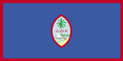
description: the territorial flag features a dark blue background bordered by a narrow red line on all sides; at the center lies a red-bordered, pointed vertical ellipse showcasing a beach scene, an proa (an outrigger canoe with a sail), and a palm tree; the word GUAM, colored red, is positioned centrally within the ellipse; the proa is depicted sailing in Agana Bay with Puntan Dos Amantes promontory in the background
meaning: blue symbolizes the sea, while red represents the blood shed in the struggle against oppression; the central emblem is designed to resemble a Chamorro sling stone, a traditional weapon used for defense or hunting
Capital
name
Hagatna (Agana)
etymology
the name Hagatna originates from the Chamorro term haga, which translates to "life's blood" and signifies the town's position as the island's governmental hub
time difference
UTC+10 (15 hours ahead of Washington, DC, during Standard Time)
geographic coordinates
13 28 N, 144 44 E
Suffrage
18 years of age; universal
Citizenship
see United States
Constitution
history
effective 1 July 1950 (Guam Act of 1950 serves as a constitution)
Country name
etymology
the island's indigenous Chamorro name, Guahan (meaning "we have"), was altered to Guam in the 1898 Treaty of Paris, when Spain ceded Guam, Cuba, Puerto Rico, and the Philippines to the United States
abbreviation
GU
local long form
none
local short form
Guahan
conventional long form
none
conventional short form
Guam
Independence
none (territory of the US)
Legal system
the legal system is based on common law influenced by the US framework; US federal laws are applicable
Government type
an unincorporated organized territory of the United States with local self-governance; it operates under a republican structure of territorial government, which includes distinct executive, legislative, and judicial branches
Judicial branch
highest court(s)
Supreme Court of Guam (consists of 3 justices)
subordinate courts
Superior Court of Guam (which comprises various divisions); US Federal District Court for the District of Guam (a US territorial court; appeals from this court are reviewed by the US Court of Appeals for the Ninth Circuit)
judge selection and term of office
justices are designated by the governor and require confirmation from the Guam legislature; justices serve for life but are subject to retention elections every decade
Executive branch
cabinet
Cabinet appointed by the governor with the consent of the Legislature
chief of state
President Donald J. TRUMP (since 20 January 2025)
election results
2022: Lourdes LEON GUERRERO was reelected as governor; vote percentages - Lourdes LEON GUERRERO (Democratic Party) 55%, Felix CAMACHO (Republican Party) 44%; Josh TENORIO (Democratic Party) was elected as lieutenant governor
2018: Lourdes LEON GUERRERO won the gubernatorial election; vote percentages - Lourdes LEON GUERRERO (Democratic Party) 50.7%, Ray TENORIO (Republican Party) 26.4%; Josh TENORIO (Democratic Party) was elected lieutenant governor
head of government
Governor Lourdes LEON GUERRERO (since 7 January 2019)
most recent election date
gubernatorial: 8 November 2022
election/appointment process
the president and vice president are chosen indirectly through an Electoral College from each state, serving a term of 4 years (eligible for a second term); according to the US Constitution, residents of unincorporated territories, such as Guam, do not vote in presidential elections, although they can participate in the Democratic and Republican primary elections; the governor and lieutenant governor are elected together via absolute majority vote, with a possibility of two rounds, for a 4-year term (eligible for two consecutive terms)
expected date of next election
gubernatorial: 3 November 2026
National holiday
Discovery Day (also known as Magellan Day), celebrated on the first Monday of March, commemorates the year 1521
Dependency status
an unincorporated, organized territory of the United States, where the Office of Insular Affairs within the US Department of the Interior manages policy relations between Guam and the Federal government
National color(s)
deep blue, red
Political parties
Democratic Party
Republican Party
Legislative branch
term in office
2 years
number of seats
15 (directly elected)
electoral system
plurality/majority
legislature name
Legislature of Guam (Liheslaturan Guahan)
scope of elections
full renewal
legislative structure
unicameral
most recent election date
11/8/2022
expected date of next election
November 2024
percentage of women in chamber
40%
parties elected and seats per party
Democratic Party (9); Republican Party (6)
National anthem(s)
title
"The Star-Spangled Banner"
history
the official anthem, reflecting its status as a US territory, is played prior to "Stand, Ye Guamanians"
lyrics/music
Francis Scott KEY/John Stafford SMITH
National symbol(s)
coconut tree
Diplomatic representation in the US
none (territory of the US)
Diplomatic representation from the US
embassy
none (territory of the US)
International organization participation
AOSIS (observer), IOC, PIF (observer), SPC, UPU
Economy
Budget
revenues
$1.24 billion (2016 est.)
expenditures
$1.299 billion (2016 est.)
Exports
Exports 2020
$379 million (2020 est.)
Exports 2021
$193 million (2021 est.)
Exports 2022
$545 million (2022 est.)
Imports
Imports 2020
$3.388 billion (2020 est.)
Imports 2021
$3.662 billion (2021 est.)
Imports 2022
$4.421 billion (2022 est.)
Industries
national defense, tourism, construction, transshipment services, concrete production, printing and publishing, food processing, textiles
Labor force
77,700 (2024 est.)
Public debt
Public debt 2013
32.1% of GDP (2013)
Exchange rates
the currency in use is the US dollar
Economic overview
small island economy in the Pacific with US territorial status; a high-income economy reliant on tourism; significantly impacted by disruptions from COVID-19; has revitalized several industries through vaccination tourism; the domestic economic structure is supported by various military installations; an economy that is environmentally vulnerable
Unemployment rate
Unemployment rate 2022
5.5% (2022 est.)
Unemployment rate 2023
5.4% (2023 est.)
Unemployment rate 2024
5.6% (2024 est.)
Exports - partners
Taiwan 42%, Hong Kong 12%, Philippines 11%, Italy 8%, Australia 6% (2023)
Imports - partners
Singapore 52%, Japan 15%, Malaysia 6%, Taiwan 4%, Greece 4% (2023)
Real GDP per capita
Real GDP per capita 2014
$34,400 (2014 est.)
Real GDP per capita 2015
$35,200 (2015 est.)
Real GDP per capita 2016
$35,600 (2016 est.)
Real GDP growth rate
Real GDP growth rate 2020
-10.5% (2020 est.)
Real GDP growth rate 2021
2.1% (2021 est.)
Real GDP growth rate 2022
5.1% (2022 est.)
Agricultural products
fruits, copra, vegetables; eggs, pork, poultry, beef
Exports - commodities
scrap iron, scrap copper, trunks and cases (2023)
Imports - commodities
refined petroleum, cars, trunks and cases, gas turbines, flavored water (2023)
GDP (official exchange rate)
$6.91 billion (2022 est.)
Average household expenditures
on food
34.6% of household expenditures (2021 est.)
on alcohol and tobacco
1.3% of household expenditures (2021 est.)
Youth unemployment rate (ages 15-24)
male
13.3% (2024 est.)
total
13.7% (2024 est.)
female
14.1% (2024 est.)
Energy
Petroleum
refined petroleum consumption
11,000 bbl/day (2023 est.)
Electricity
consumption
1.715 billion kWh (2023 est.)
installed generating capacity
525,000 kW (2023 est.)
transmission/distribution losses
90.023 million kWh (2023 est.)
Electricity access
electrification - total population
100% (2022 est.)
Energy consumption per capita
Total energy consumption per capita 2019
150.555 million Btu/person (2019 est.)
Electricity generation sources
wind
0.1% of total installed capacity (2023 est.)
solar
7.8% of total installed capacity (2023 est.)
fossil fuels
92.1% of total installed capacity (2023 est.)
Communications
Internet users
percent of population
81% (2017 est.)
Broadcast media
approximately twelve television channels, including digital options; multi-channel cable television services are accessible; around 20 radio stations
Internet country code
.gu
Telephones - fixed lines
total subscriptions
70,000 (2021 est.)
subscriptions per 100 inhabitants
43 (2022 est.)
Telephones - mobile cellular
total subscriptions
98,000 (2009 est.)
subscriptions per 100 inhabitants
62 (2009 est.)
Broadband - fixed subscriptions
total
3,000 (2022 est.)
subscriptions per 100 inhabitants
2 (2022 est.)
Transportation
Ports
large
0
small
0
medium
1
key ports
Apra Harbor
very small
0
total ports
1 (2024)
ports with oil terminals
1
Airports
3 (2025)
Heliports
2 (2025)
Merchant marine
total
3 (2023)
by type
other 3
Civil aircraft registration country code prefix
N
Military & Security
Military - note
The United States Armed Forces deploys thousands of active-duty service members alongside numerous bases and facilities situated on the island.
Military and security forces
Guam Police Department (GPD); Guam (US) National Guard