CapitalPago Pago
LanguagesSamoan , English, Tongan, other Pacific Islander, Asian languages, other
Governmentan unincorporated, unorganized Territory of the US that exercises local self-governance; it operates under a republican form of territorial governance with distinct executive, legislative, and judicial branches
Bamwor Indexes
American Samoa — Q1 2026
IBEUBamwor Urban Scale Index
26.58%
Rank #53 of 237
View full ranking →
IBCPBamwor Population Concentration Index
73.35%
Rank #30 of 237
View full ranking →
IBDABamwor Settlement Density Index
665.18per 1K km²
Rank #26 of 241
View full ranking →
IBCXBamwor Country Complexity Index
33.89/100
Rank #206 of 234
View full ranking →
American Samoa Intelligence Report
Download PDF with 20+ statistics, rankings & proprietary indices
Introduction
Background
Tutuila, recognized as the largest island in American Samoa, was inhabited as early as 1000 B.C. This island became a haven for exiled leaders and vanquished warriors from other Samoan islands. The Manu’a Islands, which are also part of American Samoa, developed a traditional chiefdom that preserved its independence by managing oceanic commerce. Dutch explorer Jacob ROGGEVEEN was the first European to navigate the waters of the Manu’a Islands in 1722, followed by French explorer Louis Antoine DE BOUGAINVILLE in 1768. The arrival of whalers and missionaries in American Samoa occurred during the 1830s; however, American and European traders often preferred the port of Apia, now part of independent Samoa, over the more modestly developed Pago Pago located on Tutuila. In the mid-19th century, a conflict erupted in Samoa regarding control over the Samoan archipelago, with various chiefs receiving backing from Germany, the United Kingdom, and the United States. In 1872, the high chief of Tutuila proposed to grant the US exclusive rights to Pago Pago in exchange for protection, but this offer was declined. When hostilities resumed, the US conceded to the chief’s request in 1878 and established a coaling station at Pago Pago. In 1899, amid ongoing succession disputes, Germany and the US reached an agreement to partition the Samoan islands, while the UK relinquished its claims in return for territories in the Solomon Islands. The local chiefs of Tutuila formally ceded their lands to the US in 1900, and the chief of Manu’a followed suit in 1904. The territory was officially designated as “American Samoa” in 1911.
The administration of the territory was conducted through the Department of the Navy. In 1949, an initiative was made to organize the territory and grant it formal self-governance, but local chiefs played a role in thwarting this proposal in the US Congress. Control was shifted to the Department of the Interior in 1951, and in 1967, American Samoa ratified a constitution that offers substantial protections for traditional Samoan land-tenure systems, language, and cultural practices. In 1977, after four attempts, voters successfully passed a measure to elect their governor directly. Despite these developments, American Samoa remains officially classified as an unorganized territory, and individuals born there are recognized as US nationals rather than US citizens.
Geography
Area
land
224 sq km
water
0 sq km
total
224 sq km
Climate
tropical marine climate, influenced by southeast trade winds; the yearly average precipitation is approximately 3 meters; the wet season occurs from November to April, while the dry season spans May to October; minimal seasonal temperature fluctuations
Terrain
comprises five volcanic islands characterized by steep peaks and limited coastal plains, in addition to two coral atolls (Rose Atoll, Swains Island)
Land use
other
6% (2023 est.)
forest
79.2% (2023 est.)
agricultural land
14.8% (2023 est.)
agricultural land: arable land
arable land: 5.2% (2023 est.)
agricultural land: permanent crops
permanent crops: 9.6% (2023 est.)
agricultural land: permanent pasture
permanent pasture: 0% (2023 est.)
Location
located in Oceania, this group of islands is situated in the South Pacific Ocean, roughly equidistant from Hawaii and New Zealand
Coastline
116 km
Elevation
lowest point
Pacific Ocean 0 m
highest point
Lata Mountain 964 m
Irrigated land
0 sq km (2022)
Map references
Oceania
Land boundaries
total
0 km
Maritime claims
territorial sea
12 nm
exclusive economic zone
200 nm
Natural hazards
cyclones are prevalent from December through March
volcanism: there is minimal volcanic activity on Ofu and Olosega Islands; both have not erupted since the 19th century
Geography - note
Pago Pago boasts one of the finest natural deepwater harbors in the South Pacific Ocean, offering shelter from turbulent seas due to its shape and protection from strong winds provided by surrounding mountains; it holds a strategic position in the South Pacific Ocean
Natural resources
pumice, pumicite
Area - comparative
somewhat larger than Washington, D.C.
Geographic coordinates
14 20 S, 170 00 W
People & Society
Languages
Samoan 87.9% (intimately connected to Hawaiian and various other Polynesian tongues), English 3.3%, Tongan 2.1%, other Pacific Islander 4.1%, Asian languages 2.1%, other 0.5% (2020 est.)
Religions
Christian 98.3%, other <1%, unaffiliated <1% (2020 est.)
Sex ratio
at birth
1.06 male(s)/female
0-14 years
1.07 male(s)/female
15-64 years
0.97 male(s)/female
total population
0.99 male(s)/female (2024 est.)
65 years and over
0.88 male(s)/female
Birth rate
15.3 births/1,000 population (2025 est.)
Death rate
6.4 deaths/1,000 population (2025 est.)
Median age
male
29.4 years
total
30.6 years (2025 est.)
female
30.6 years
Population
male
21,478
total
43,268 (2025 est.)
female
21,790
Nationality
noun
American Samoan(s) (US nationals)
adjective
American Samoan
Urbanization
urban population
87.2% of total population (2023)
rate of urbanization
0.26% annual rate of change (2020-25 est.)
Age structure
0-14 years
25.3% (male 5,738/female 5,387)
15-64 years
66% (male 14,291/female 14,679)
65 years and over
8.7% (2024 est.) (male 1,775/female 2,025)
Ethnic groups
Pacific Islander 88.7% (comprising Samoan 83.2%, Tongan 2.2%, other 3.3%), Asian 5.8% (including Filipino 3.4%, other 2.4%), mixed 4.4%, other 1.1% (2020 est.)
Dependency ratios
total dependency ratio
51.3 (2025 est.)
youth dependency ratio
37.5 (2025 est.)
potential support ratio
7.2 (2025 est.)
elderly dependency ratio
13.8 (2025 est.)
Net migration rate
-22.23 migrant(s)/1,000 population (2025 est.)
Total fertility rate
1.99 children born/woman (2025 est.)
Drinking water source
improved: total
total: 99.8% of population
unimproved: total
total: 0.2% of population (2020 est.)
Infant mortality rate
male
11.7 deaths/1,000 live births
total
9.5 deaths/1,000 live births (2025 est.)
female
7.6 deaths/1,000 live births
Population growth rate
-1.33% (2025 est.)
Gross reproduction rate
0.96 (2025 est.)
Life expectancy at birth
male
73.4 years
female
78.5 years
total population
75.8 years (2024 est.)
Sanitation facility access
improved: total
total: 98.5% of population (2022 est.)
unimproved: total
total: 1.5% of population (2022 est.)
Major urban areas - population
49,000 PAGO PAGO (capital) (2018)
Currently married women (ages 15-49)
47.4% (2020 est.)
Environment
Climate
The climate is tropical marine and is influenced by southeast trade winds; the annual precipitation is approximately 3 meters; the rainy period spans from November to April, while the dry period extends from May to October; there is minimal variation in temperature throughout the seasons.
Land use
other
6% (2023 est.)
forest
79.2% (2023 est.)
agricultural land
14.8% (2023 est.)
agricultural land: arable land
arable land: 5.2% (2023 est.)
agricultural land: permanent crops
permanent crops: 9.6% (2023 est.)
agricultural land: permanent pasture
permanent pasture: 0% (2023 est.)
Urbanization
urban population
87.2% of total population (2023)
rate of urbanization
0.26% annual rate of change (2020-25 est.)
Waste and recycling
municipal solid waste generated annually
19,000 tons (2024 est.)
Environmental issues
There is a restricted availability of potable water; issues related to pollution; challenges in waste management; modifications to coastal areas and streams; and problems with soil erosion.
Carbon dioxide emissions
total emissions
389,000 metric tonnes of CO2 (2023 est.)
from petroleum and other liquids
389,000 metric tonnes of CO2 (2023 est.)
Government
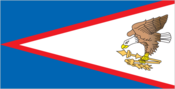
Flag
description: a prominent white triangle outlined in red is positioned on the right side, extending towards the left, set against a dark blue background; a bald eagle, grasping a Samoan war club (fa'alaufa'i) and a coconut-fiber fly whisk (fue), is depicted on the right side of the flag
meaning: the war club and fly whisk serve as traditional symbols of authority in Samoan culture; the eagle, carrying both items, alludes to the Great Seal of the United States and symbolizes the connection between the United States and American Samoa; the color scheme of red, white, and blue is a common representation in both nations
Capital
name
Pago Pago
time difference
UTC-11 (6 hours behind Washington, DC, during Standard Time)
geographic coordinates
14 16 S, 170 42 W
Suffrage
18 years of age; universal
Citizenship
see United States
note: as per US Code Title 8, Section 1408, individuals born in American Samoa are recognized as US nationals but do not hold US citizenship
Constitution
history
adopted 17 October 1960; revised 1 July 1967
amendment process
initiatives can be proposed by either chamber of the Legislative Assembly; for passage, a three-fifths majority vote is required from each house's members, alongside a simple majority in a referendum, approval from the US Secretary of the Interior, and ultimately, an act from the US Congress
Country name
former
Eastern Samoa
etymology
the interpretation of the name is subject to debate; one perspective posits that sa translates to "sacred" and moa to "center," suggesting the name could mean "Holy Center"; alternatively, it has been proposed that it refers to the "place of the sacred moa bird" from Polynesian lore; however, it is also possible that the name predates the Polynesian era (prior to 1000 B.C.), with sa'a meaning "tribe or people" and moa indicating "deep sea," or "people of the deep sea"
abbreviation
AS
conventional long form
American Samoa
conventional short form
American Samoa
Independence
none (territory of the US)
Legal system
a mixed legal framework consisting of US common law and customary law
Government type
an unincorporated, unorganized Territory of the US that exercises local self-governance; it operates under a republican form of territorial governance with distinct executive, legislative, and judicial branches
Judicial branch
highest court(s)
High Court of American Samoa (comprising the chief justice, associate chief justice, and six Samoan associate judges, organized into trial, family, drug, and appellate divisions)
subordinate courts
district and village courts
judge selection and term of office
the chief justice and associate chief justice are appointed for life by the US Secretary of the Interior; Samoan associate judges are appointed by the governor to serve for life
Executive branch
cabinet
Cabinet consists of 12 department directors appointed by the governor with the consent of the Legislature or Fono
chief of state
President Donald J. TRUMP (since 20 January 2025)
election results
Lemanu Peleti MAUGA elected governor in first round; percent of vote - Lemanu Peleti MAUGA (independent) 60.3%, Gaoteote Palaie TOFAU (independent) 21.9%, I'aulualo Fa'afetai TALIA (independent) 12.3%
head of government
Governor Nikolao PULA (since 3 January 2025)
most recent election date
19 November 2024
election/appointment process
the president and vice president are indirectly elected on the same ballot by an Electoral College of 'electors' selected from each state, serving a 4-year term (with eligibility for a second term); under the US Constitution, residents of unincorporated territories like American Samoa cannot vote in US presidential and vice-presidential elections; however, they are permitted to participate in the Democratic and Republican presidential primary elections; the governor and lieutenant governor are directly elected on the same ballot through an absolute-majority popular vote, potentially requiring two rounds, for a 4-year term (also eligible for a second term)
expected date of next election
November 2028
National holiday
Flag Day, 17 April (1900)
Dependency status
an unincorporated, unorganized Territory of the US; overseen by the Office of Insular Affairs within the US Department of the Interior
National color(s)
red, white, blue
Political parties
Democratic Party
Republican Party
Legislative branch
National anthem(s)
title
"The Star-Spangled Banner"
history
official anthem, as a US territory
lyrics/music
Francis Scott KEY/John Stafford SMITH
National symbol(s)
a fue (coconut fiber fly whisk that represents wisdom) crossed with a to'oto'o (staff that represents authority)
Administrative divisions
there are no first-order administrative divisions as classified by the US government, but three districts and two islands* are recognized as second-order divisions; Eastern, Manu'a, Rose Island*, Swains Island*, Western
Diplomatic representation in the US
none (territory of the US)
Diplomatic representation from the US
embassy
none (territory of the US)
International organization participation
AOSIS (observer), Interpol (subbureau), IOC, PIF (observer), SPC
Economy
Budget
revenues
$249 million (2016 est.)
expenditures
$262.5 million (2016 est.)
Exports
Exports 2020
$427 million (2020 est.)
Exports 2021
$332 million (2021 est.)
Exports 2022
$409 million (2022 est.)
Imports
Imports 2020
$686 million (2020 est.)
Imports 2021
$694 million (2021 est.)
Imports 2022
$677 million (2022 est.)
Industries
tuna canneries (primarily dependent on foreign fishing fleets), handicrafts
Exchange rates
the US dollar is utilized
Economic overview
an economy reliant on tourism, tuna, and government services; ongoing economic downturn; a tuna canning sector that is susceptible to vulnerabilities; significant territorial government involvement; minimum wage hikes anticipated to reach federal benchmarks by 2036
Exports - partners
Australia 31%, UK 18%, Tanzania 9%, UAE 7%, Senegal 6% (2023)
Imports - partners
Singapore 28%, NZ 15%, Fiji 14%, Taiwan 11%, Malaysia 11% (2023)
Real GDP growth rate
Real GDP growth rate 2020
4.4% (2020 est.)
Real GDP growth rate 2021
-0.8% (2021 est.)
Real GDP growth rate 2022
1.7% (2022 est.)
Agricultural products
bananas, coconuts, vegetables, taro, breadfruit, yams, copra, pineapples, papayas; dairy products, livestock
Exports - commodities
animal meal, aluminum, refined petroleum, gas turbines, broadcasting equipment (2023)
Imports - commodities
refined petroleum, fish, paper containers, wood, construction vehicles (2023)
GDP (official exchange rate)
$871 million (2022 est.)
Real GDP (purchasing power parity)
Real GDP (purchasing power parity) 2014
$666.9 billion (2014 est.)
Real GDP (purchasing power parity) 2015
$674.9 million (2015 est.)
Real GDP (purchasing power parity) 2016
$658 million (2016 est.)
Energy
Petroleum
refined petroleum consumption
3,000 bbl/day (2023 est.)
Electricity
consumption
157.697 million kWh (2023 est.)
installed generating capacity
50,000 kW (2023 est.)
transmission/distribution losses
13.975 million kWh (2023 est.)
Energy consumption per capita
Total energy consumption per capita 2019
89.105 million Btu/person (2019 est.)
Electricity generation sources
solar
2.9% of total installed capacity (2023 est.)
fossil fuels
97.1% of total installed capacity (2023 est.)
Communications
Internet users
percent of population
40.3% (1990 est.)
Broadcast media
Three television stations exist; multi-channel subscription television services are accessible; approximately twelve radio stations operate, including a number of repeater stations.
Internet country code
.as
Telephones - fixed lines
total subscriptions
9,690 (2022 est.)
subscriptions per 100 inhabitants
20 (2022 est.)
Telephones - mobile cellular
total subscriptions
2,250 (2004 est.)
subscriptions per 100 inhabitants
4 (2004 est.)
Transportation
Ports
large
0
small
1
medium
0
key ports
Pago Pago Harbor
very small
0
total ports
1 (2024)
ports with oil terminals
1
Airports
3 (2025)
Military & Security
Military - note
The responsibility for defense lies with the United States.