CapitalThe Settlement (Flying Fish Cove)
LanguagesEnglish, Mandarin, Malay, Cantonese, Min Nan, Tagalog, other, unspecified
CurrencyAustralian dollars
Governmentnon-self-governing overseas territory of Australia
Bamwor Indexes
Christmas Island — Q1 2026
IBEUBamwor Urban Scale Index
29.55%
Rank #46 of 237
View full ranking →
IBCPBamwor Population Concentration Index
29.55%
Rank #118 of 237
View full ranking →
IBDABamwor Settlement Density Index
51.85per 1K km²
Rank #158 of 241
View full ranking →
IBCXBamwor Country Complexity Index
15.28/100
Rank #230 of 234
View full ranking →
Christmas Island Intelligence Report
Download PDF with 20+ statistics, rankings & proprietary indices
Introduction
Background
Although Europeans sighted Christmas Island in 1615, it was named for the day of its rediscovery in 1643. Steep cliffs and dense jungle hampered attempts to explore the island over the next two centuries. The discovery of phosphate on the island in 1887 led to the UK annexing it the following year. In 1898, 200 Chinese indentured servants were brought in to work the mines, along with Malays, Sikhs, and a small number of Europeans. The UK administered Christmas Island from Singapore.
Japan invaded the island in 1942, but islanders sabotaged Japanese mining operations, making the mines relatively unproductive. After World War II, Australia and New Zealand bought the company mining the phosphate, and in 1958, the UK transferred sovereignty from Singapore to Australia in exchange for $20 million to compensate for the loss of future phosphate income. In 1980, Australia set up the Christmas Island National Park and expanded its boundaries throughout the 1980s until it covered more than 60% of the island’s territory. The phosphate mine was closed in 1987 because of environmental concerns, and Australia has rejected several efforts to reopen it.
In the 1980s, boats of asylum seekers started landing on Christmas Island, and the migrants claimed refugee status because they were on Australian territory. In 2001, Australia declared Christmas Island to be outside the Australian migration zone and built an immigration detention center on the island. Completed in 2008, the controversial detention center was closed in 2018 but then reopened in 2019. In 2020, the center served as a coronavirus quarantine facility for Australian citizens evacuated from China.
Geography
Area
land
135 sq km
water
0 sq km
total
135 sq km
Climate
characterized by a tropical climate featuring a wet period from December to April and a dry period; heat and humidity are tempered by trade winds
Terrain
steep coastal cliffs rise sharply to meet the central plateau
Land use
other
100% (2018 est.)
agricultural land
0% (2018 est.)
Location
Southeast Asia, an island situated in the Indian Ocean, south of Indonesia
Coastline
138.9 km
Elevation
lowest point
Indian Ocean 0 m
highest point
Murray Hill 361 m
Irrigated land
NA
Map references
Southeast Asia
Land boundaries
total
0 km
Maritime claims
contiguous zone
12 nm
territorial sea
12 nm
exclusive fishing zone
200 nm
Natural hazards
the narrow fringing reef that encircles the island may pose a maritime risk
Geography - note
positioned along significant maritime routes in the Indian Ocean
Natural resources
phosphate resources, coastal beaches
Area - comparative
approximately three-quarters the area of Washington, D.C.
Geographic coordinates
10 30 S, 105 40 E
Population distribution
the majority of the inhabitants reside at the northern end of the island
People & Society
Languages
English (official) 27.6%, Mandarin 17.2%, Malay 17.1%, Cantonese 3.9%, Min Nan 1.6%, Tagalog 1%, other 4.5%, unspecified 27.1% (2016 estimate)
Religions
Muslim 19.4%, Buddhist 18.3%, Roman Catholic 8.8%, Protestant 6.5% (includes Anglican 3.6%, Uniting Church 1.2%, other 1.7%), other Christian 3.3%, other 0.6%, none 15.3%, unspecified 27.7% (2016 est.)
Median age
total
38 years (2021 est.)
Population
male
1,007
total
1,692 (2021 est.)
female
685
Nationality
noun
Christmas Islander(s)
adjective
Christmas Island
Age structure
0-14 years
16.6%
15-64 years
70.4%
65 years and over
13% (2021)
Ethnic groups
Chinese 70%, European 20%, Malay 10% (2001)
Population growth rate
1.11% (2014 est.)
Population distribution
the largest portion of the population resides at the northern end of the island
Environment
Climate
characterized by a tropical climate featuring a wet season from December to April and a dry season; the heat and humidity are alleviated by trade winds
Land use
other
100% (2018 est.)
agricultural land
0% (2018 est.)
Environmental issues
deterioration of rainforest ecosystems; effects of phosphate extraction
Government
Flag
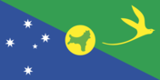
description: territorial flag; sectioned diagonally from the upper left to the lower right; the upper triangle is green featuring a yellow silhouette of the golden bosun bird; the lower triangle is blue displaying the Southern Cross constellation, a symbol of Australia; a centered yellow circle presents a green outline of the island
Capital
name
The Settlement (Flying Fish Cove)
etymology
Flying Fish Cove was named after a British explorer's ship in 1886
time difference
UTC+7 (12 hours ahead of Washington, DC, during Standard Time)
geographic coordinates
10 25 S, 105 43 E
Suffrage
18 years of age
Citizenship
see Australia
Constitution
history
1 October 1958 (Christmas Island Act 1958)
Country name
etymology
designated by English Captain William MYNORS to commemorate its rediscovery on Christmas Day (25 December 1643); Europeans had observed the island as early as 1615
conventional long form
Territory of Christmas Island
conventional short form
Christmas Island
Independence
none (territory of Australia)
Legal system
the system operates under the jurisdiction of the governor general of Australia and Australian law
Government type
non-self-governing overseas territory of Australia
Judicial branch
highest court(s)
in accordance with the Territorial Law Reform Act 1992, Western Australia offers judicial services as required for the island, encompassing the Supreme Court and subordinate courts (District Court, Magistrate Court, Family Court, Children's Court, and Coroners' Court)
Executive branch
cabinet
NA
chief of state
King CHARLES III (since 8 September 2022); represented by Governor-General of the Commonwealth of Australia General Sam MOSTYN (since 1 July 2024)
head of government
Administrator Farzian ZAINAL (since 11 May 2023)
election/appointment process
the monarchy is hereditary; the governor-general is appointed by the monarch based on the recommendation of the Australian prime minister; an administrator is designated by the governor-general of Australia for a term of 2 years and acts on behalf of the monarch and Australia
National holiday
Australia Day (marks the arrival of the First Fleet of Australian settlers), 26 January (1788)
Dependency status
non-self-governing territory of Australia; governed from Canberra by the Department of Infrastructure, Transport, Cities & Regional Development
Political parties
none
Legislative branch
term in office
4 years
number of seats
9 (directly elected)
electoral system
plurality/majority
legislature name
Christmas Island Shire Council
scope of elections
partial renewal
legislative structure
unicameral
most recent election date
10/2023
expected date of next election
October 2025
percentage of women in chamber
13%
parties elected and seats per party
independent (9)
National anthem(s)
title
"God Save the King"
history
royal anthem, as an Australian territory
lyrics/music
unknown
National symbol(s)
golden bosun bird
Diplomatic representation in the US
none (territory of Australia)
Diplomatic representation from the US
embassy
none (territory of Australia)
International organization participation
none
Economy
Industries
tourism, phosphate mining (approaching depletion)
Exchange rates
Currency
Australian dollars (AUD) per US dollar -
Exchange rates 2020
1.453 (2020 est.)
Exchange rates 2021
1.331 (2021 est.)
Exchange rates 2022
1.442 (2022 est.)
Exchange rates 2023
1.505 (2023 est.)
Exchange rates 2024
1.515 (2024 est.)
Economic overview
affluent Australian territorial economy; growth fueled by government services and phosphate extraction; houses Australia’s Immigration Detention Centre; rising tourism and public sector investments; ongoing environmental safeguards
Exports - partners
Indonesia 30%, USA 26%, Malaysia 12%, Ireland 8%, UK 7% (2023)
Imports - partners
USA 58%, Australia 40%, Malaysia 1%, Fiji 0%, Singapore 0% (2023)
Exports - commodities
fertilizers, paintings, amine compounds (2023)
Imports - commodities
aircraft, refined petroleum, automobiles, air conditioning units, plastic goods (2023)
Communications
Internet users
percent of population
78.6% (2016 est.)
Broadcast media
One community radio station; satellite transmissions of numerous Australian radio and television stations (2017)
Internet country code
.cx
Transportation
Ports
large
0
small
0
medium
1
key ports
Flying Fish Cove
very small
0
total ports
1 (2024)
ports with oil terminals
0
Airports
1 (2025)
Railways
total
18 km (2017)
standard gauge
18 km (2017) 1.435-m (not in operation)
Military & Security
Military - note
The obligation for defense lies with Australia.