CapitalLilongwe
LanguagesEnglish , Chewa , Lambya, Lomwe, Ngoni, Nkhonde, Nyakyusa, Nyanja, Sena, Tonga, Tumbuka, Yao
CurrencyMalawian kwachas
Governmentpresidential republic
Bamwor Indexes
Malawi — Q1 2026
IBEUBamwor Urban Scale Index
5.13%
Rank #208 of 237
View full ranking →
IBCPBamwor Population Concentration Index
11.28%
Rank #213 of 237
View full ranking →
IBDABamwor Settlement Density Index
67.35per 1K km²
Rank #140 of 241
View full ranking →
IBCXBamwor Country Complexity Index
57.66/100
Rank #130 of 234
View full ranking →
IBEEBamwor Economic Stability Index
78.41/100
Rank #200 of 220
View full ranking →
IBDIBamwor Digital Infrastructure Index
28.01/100
Rank #198 of 206
View full ranking →
IBEDBamwor Education Index
48.93/100
Rank #93 of 119
View full ranking →
IBSABamwor Healthcare Index
60.61/100
Rank #165 of 218
View full ranking →
Malawi Intelligence Report
Download PDF with 20+ statistics, rankings & proprietary indices
Introduction
Background
Malawi derives its name from the Chewa term for flames and is associated with the Maravi people, the originators of the Chewa language. The Maravi established themselves in the area now recognized as Malawi around the year 1400, during one of the later phases of Bantu migration throughout central and southern Africa. A formidable Maravi kingdom was founded circa 1500, reaching its peak around 1700, when it governed territories that now comprise southern and central Malawi, as well as parts of neighboring Mozambique and Zambia. The kingdom's decline was precipitated by disruptions caused by the growing global market in enslaved individuals. In the early 1800s, extensive conflict in southern Africa led to the displacement of various Ngoni ethnic groups, some of which migrated into Malawi, further weakening the Maravi. Members of the Yao ethnic group, who had been trading with Malawi from Mozambique for a considerable time, began to establish a significant presence in Malawi in the mid-1800s, introducing Islam, followed by the Lomwe ethnic group. The mid-1800s also saw an increase in British missionary and trading activities around Lake Nyasa, and in 1891, Britain proclaimed a protectorate known as British Central Africa over what is now Malawi. The territory was renamed Nyasaland by the British in 1907, and from 1953 to 1963, it was incorporated into the colonial Federation of Rhodesia and Nyasaland, which included present-day Zambia and Zimbabwe, before achieving independence as Malawi in 1964.
At the time of independence, Hastings Kamuzu BANDA served as prime minister and later became president when the nation transitioned to a republic in 1966. He established a one-party system under his Malawi Congress Party (MCP) and was designated president for life. Following thirty years of one-party governance, the country conducted multiparty presidential and parliamentary elections in 1994, based on a provisional constitution that took full effect the subsequent year. Bakili MULUZI, representing the United Democratic Front party, emerged as the first freely elected president of Malawi by defeating BANDA in the 1994 elections; he secured reelection in 1999. President Bingu wa MUTHARIKA was elected in 2004 and won a second term in 2009. His sudden death in 2012 led to Vice President Joyce BANDA assuming the presidency. MUTHARIKA's brother, Peter MUTHARIKA, triumphed over BANDA in the 2014 election. Peter MUTHARIKA was reelected in a contentious 2019 election that sparked nationwide protests. The courts mandated a new election, resulting in Lazarus CHAKWERA of the MCP being elected president in 2020. Major challenges facing Malawi include population growth, rising pressure on agricultural lands, corruption, and the HIV/AIDS epidemic.
Geography
Area
land
94,080 sq km
water
24,404 sq km
total
118,484 sq km
Climate
subtropical climate characterized by a rainy season from November to May and a dry season from May to November
Terrain
a narrow and elongated plateau featuring rolling plains, rounded hills, and several mountains
Land use
other
13.4% (2023 est.)
forest
22.4% (2023 est.)
agricultural land
64.2% (2023 est.)
agricultural land: arable land
arable land: 42.4% (2023 est.)
agricultural land: permanent crops
permanent crops: 2.1% (2023 est.)
agricultural land: permanent pasture
permanent pasture: 19.6% (2023 est.)
Location
located in Southern Africa, to the east of Zambia, and to the west and north of Mozambique
Coastline
0 km (landlocked)
Elevation
lowest point
junction of the Shire River and international boundary with Mozambique 37 m
highest point
Sapitwa (Mount Mlanje) 3,002 m
mean elevation
779 m
Irrigated land
740 sq km (2012)
Map references
Africa
Land boundaries
total
2,857 km
border countries
bordering Mozambique at 1,498 km; Tanzania at 512 km; and Zambia at 847 km
Maritime claims
none (landlocked)
Natural hazards
experiences flooding, droughts, and earthquakes
Geography - note
a landlocked nation; Lake Nyasa, approximately 580 km (360 mi) in length, represents the country's most significant geographical feature and is home to more fish species than any other lake globally
Natural resources
rich in limestone, cultivable land, hydropower resources, and untapped reserves of uranium, coal, and bauxite
Area - comparative
slightly less extensive than Pennsylvania
Geographic coordinates
13 30 S, 34 00 E
Population distribution
the highest population density is found south of Lake Nyasa, as illustrated in the accompanying population distribution map
Major lakes (area sq km)
salt water lake(s)
Lake Chilwa - 1,040 sq km
fresh water lake(s)
Lake Malawi, which it shares with Mozambique and Tanzania, spans 22,490 square kilometers
Major watersheds (area sq km)
Indian Ocean drainage
Zambezi (1,332,412 sq km)
Atlantic Ocean drainage
Congo (3,730,881 sq km)
Major rivers (by length in km)
Zambezi River, shared with Zambia [s], Angola, Zimbabwe, Namibia, Tanzania, and Mozambique [m], measures 2,740 km
note: [s] indicates river source after the country name; [m] indicates river mouth after the country name
People & Society
Literacy
male
78.6% (2020 est.)
female
62.7% (2020 est.)
total population
70.2% (2020 est.)
Languages
English (official), Chewa (dominant), Lambya, Lomwe, Ngoni, Nkhonde, Nyakyusa, Nyanja, Sena, Tonga, Tumbuka, Yao
Religions
Protestant 33.5% (includes Church of Central Africa Presbyterian 14.2%, Seventh Day Adventist/Baptist 9.4%, Pentecostal 7.6%, Anglican 2.3%), Roman Catholic 17.2%, other Christian 26.6%, Muslim 13.8%, traditionalist 1.1%, other 5.6%, none 2.1% (2018 est.)
Sex ratio
at birth
1.01 male(s)/female
0-14 years
0.99 male(s)/female
15-64 years
0.96 male(s)/female
total population
0.96 male(s)/female (2024 est.)
65 years and over
0.8 male(s)/female
Birth rate
28.04 births/1,000 population (2025 est.)
Death rate
3.57 deaths/1,000 population (2025 est.)
Median age
male
20 years
total
19.4 years (2025 est.)
female
20.6 years
Population
male
10,674,594
total
21,763,309 (2024 est.)
female
11,088,715
Nationality
noun
Malawian(s)
adjective
Malawian
Tobacco use
male
11.7% (2025 est.)
total
6.3% (2025 est.)
female
1.4% (2025 est.)
Urbanization
urban population
18.3% of total population (2023)
rate of urbanization
4.41% annual rate of change (2020-25 est.)
Age structure
0-14 years
37.7% (male 4,080,567/female 4,132,710)
15-64 years
58.4% (male 6,217,761/female 6,487,273)
65 years and over
3.9% (2024 est.) (male 376,266/female 468,732)
Ethnic groups
Chewa 34.3%, Lomwe 18.8%, Yao 13.2%, Ngoni 10.4%, Tumbuka 9.2%, Sena 3.8%, Mang'anja 3.2%, Tonga 1.8%, Nyanja 1.8%, Nkhonde 1%, other 2.2%, foreign 0.3% (2018 est.)
Child marriage
men married by age 18
7% (2020)
women married by age 15
7.5% (2020)
women married by age 18
37.7% (2020)
Dependency ratios
total dependency ratio
71.3 (2024 est.)
youth dependency ratio
64.6 (2024 est.)
potential support ratio
15 (2024 est.)
elderly dependency ratio
6.7 (2024 est.)
Physician density
0.05 physicians/1,000 population (2022)
Health expenditure
Health expenditure (as % of GDP)
7.4% of GDP (2021)
Health expenditure (as % of national budget)
3.3% of national budget (2022 est.)
Net migration rate
-2.9 migrant(s)/1,000 population (2025 est.)
Total fertility rate
3.33 children born/woman (2025 est.)
Drinking water source
improved: rural
rural: 68.8% of population (2022 est.)
improved: total
total: 71.9% of population (2022 est.)
improved: urban
urban: 85.9% of population (2022 est.)
unimproved: rural
rural: 31.2% of population (2022 est.)
unimproved: total
total: 28.1% of population (2022 est.)
unimproved: urban
urban: 14.1% of population (2022 est.)
Education expenditure
Education expenditure (% GDP)
2.7% of GDP (2022 est.)
Education expenditure (% national budget)
16% national budget (2024 est.)
Infant mortality rate
male
36.4 deaths/1,000 live births
total
28.9 deaths/1,000 live births (2025 est.)
female
27.4 deaths/1,000 live births
Population growth rate
2.16% (2025 est.)
Gross reproduction rate
1.65 (2025 est.)
Population distribution
The density of the population is greatest to the south of Lake Nyasa, as illustrated in this map of population distribution.
Life expectancy at birth
male
69.9 years
female
76.1 years
total population
73 years (2024 est.)
Maternal mortality ratio
225 deaths/100,000 live births (2023 est.)
Sanitation facility access
improved: rural
rural: 73.4% of population (2022 est.)
improved: total
total: 75.8% of population (2022 est.)
improved: urban
urban: 87.1% of population (2022 est.)
unimproved: rural
rural: 26.6% of population (2022 est.)
unimproved: total
total: 24.2% of population (2022 est.)
unimproved: urban
urban: 12.9% of population (2022 est.)
Alcohol consumption per capita
beer
0.08 liters of pure alcohol (2019 est.)
wine
0 liters of pure alcohol (2019 est.)
total
2.04 liters of pure alcohol (2019 est.)
spirits
0.25 liters of pure alcohol (2019 est.)
other alcohols
1.7 liters of pure alcohol (2019 est.)
Major urban areas - population
1.276 million LILONGWE (capital), 1.031 million Blantyre-Limbe (2023)
Obesity - adult prevalence rate
5.8% (2016)
Mother's mean age at first birth
19.1 years (2015/16 est.)
Currently married women (ages 15-49)
62.1% (2020 est.)
Children under the age of 5 years underweight
11.6% (2020 est.)
School life expectancy (primary to tertiary education)
male
10 years (2021 est.)
total
10 years (2021 est.)
female
10 years (2021 est.)
Environment
Climate
sub-tropical; wet season (November through May); dry season (May through November)
Land use
other
13.4% (2023 est.)
forest
22.4% (2023 est.)
agricultural land
64.2% (2023 est.)
agricultural land: arable land
arable land: 42.4% (2023 est.)
agricultural land: permanent crops
permanent crops: 2.1% (2023 est.)
agricultural land: permanent pasture
permanent pasture: 19.6% (2023 est.)
Urbanization
urban population
18.3% of total population (2023)
rate of urbanization
4.41% annual rate of change (2020-25 est.)
Waste and recycling
municipal solid waste generated annually
1.298 million tons (2024 est.)
percent of municipal solid waste recycled
9.6% (2022 est.)
Environmental issues
deforestation; land degradation; water contamination due to agricultural runoff, sewage, and industrial waste; siltation of fish breeding areas; elevated temperatures and shifting precipitation trends
Total water withdrawal
municipal
143.1 million cubic meters (2022 est.)
industrial
47.7 million cubic meters (2022 est.)
agricultural
1.166 billion cubic meters (2022 est.)
Carbon dioxide emissions
total emissions
2.265 million metric tonnes of CO2 (2023 est.)
from coal and metallurgical coke
65,000 metric tonnes of CO2 (2023 est.)
from petroleum and other liquids
2.2 million metric tonnes of CO2 (2023 est.)
Particulate matter emissions
18.5 micrograms per cubic meter (2019 est.)
Total renewable water resources
17.28 billion cubic meters (2022 est.)
International environmental agreements
party to
Biodiversity, Climate Change, Climate Change-Kyoto Protocol, Climate Change-Paris Agreement, Comprehensive Nuclear Test Ban, Desertification, Endangered Species, Environmental Modification, Hazardous Wastes, Law of the Sea, Marine Life Conservation, Nuclear Test Ban, Ozone Layer Protection, Ship Pollution, Wetlands
signed, but not ratified
none of the selected agreements
Government
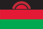
Flag
description: consists of three horizontal bands of equal width: black on top, followed by red, and green at the bottom, featuring a rising red sun positioned in the center of the black band
meaning: black represents ethnic groups, red symbolizes the blood spilled in the quest for freedom, and green signifies nature; the sun embodies the aspiration for freedom across the African continent
Capital
name
Lilongwe
etymology
derived from the Lilongwe River that traverses the city; the exact origin of the river's name remains uncertain
time difference
UTC+2 (7 hours ahead of Washington, DC, during Standard Time)
geographic coordinates
13 58 S, 33 47 E
Suffrage
18 years of age; universal
Citizenship
citizenship by birth
no
citizenship by descent only
at least one parent must be a citizen of Malawi
dual citizenship recognized
no
residency requirement for naturalization
7 years
Constitution
history
prior constitutions in 1953 (pre-independence), 1964, and 1966; the most recent was drafted between January and May 1994, approved on 16 May 1994, and came into effect on 18 May 1995
amendment process
introduced by the National Assembly; for amendments impacting constitutional articles, including state sovereignty and territory, core constitutional principles, human rights, voting rights, and the judiciary, both a majority in a referendum and a majority in the Assembly is required; for other amendments, a minimum of a two-thirds majority vote in the Assembly is necessary
Country name
former
formerly known as the British Central African Protectorate, Nyasaland Protectorate, Nyasaland
etymology
named after the Maravi people who have resided in the region since the 14th century; the term maravi translates to "flames"
local long form
Dziko la Malawi
local short form
Malawi
conventional long form
Republic of Malawi
conventional short form
Malawi
Independence
6 July 1964 (from the UK)
Legal system
a hybrid legal system combining English common law and customary law; the Supreme Court of Appeal has the authority to review legislative acts
Government type
presidential republic
Judicial branch
highest court(s)
Supreme Court of Appeal (consists of the chief justice and at least 3 judges)
subordinate courts
includes the High Court, magistrate courts, the Industrial Relations Court, and traditional or local courts at the district and city levels
judge selection and term of office
the chief justice of the Supreme Court is appointed by the president and requires confirmation from the National Assembly; other judges are appointed by the president based on recommendations from the Judicial Service Commission, which oversees judicial officers; judges serve until they reach 65 years of age
Executive branch
cabinet
Cabinet named by the president
chief of state
President Peter MUTHARIKA (since 4 October 2025)
election results
2025: Peter MUTHARIKA was elected as president; vote percentages - Peter MUTHARIKA (DPP) 56.8%, Lazarus CHAKWERA (MCP) 33.0%, Dalitso KABAMBE (UTM) 3.95%, Atupele MULUZI (UDF) 1.92%, Joyce BANDA (PP) 1.61%, others 2.72%
2020: Lazarus CHAKWERA was elected president; vote percentages - Lazarus CHAKWERA (MCP) 59.3%, Peter Mutharika (DPP) 39.9%, others 0.8%
head of government
President Peter MUTHARIKA (since 4 October 2025)
most recent election date
September 2030
election/appointment process
president directly elected by simple-majority popular vote for a 5-year term (eligible for a second term)
expected date of next election
September 2030
National holiday
Independence Day, 6 July (1964)
National color(s)
black, red, green
National heritage
total World Heritage Sites
3 (2 cultural, 1 natural)
selected World Heritage Site locales
Lake Malawi National Park (n); Chongoni Rock-Art Area (c); Mount Mulanje Cultural Landscape (c)
Political parties
Democratic Progressive Party or DPP
Malawi Congress Party or MCP
People's Party or PP
United Democratic Front or UDF
United Transformation Movement or UTM
Legislative branch
term in office
5 years
number of seats
229 (all directly elected)
electoral system
plurality/majority
legislature name
National Assembly
scope of elections
full renewal
legislative structure
unicameral
most recent election date
9/16/2025
expected date of next election
September 2025
percentage of women in chamber
21.4%
parties elected and seats per party
Democratic Progressive Party (DPP) (78); Malawi Congress Party (MCP) (52); Independents (73); Other (21)
National anthem(s)
title
"Mulungu dalitsa Malawi" (O God, Bless Our Land of Malawi)
history
adopted 1964
lyrics/music
Michael-Fredrick Paul SAUKA
National symbol(s)
lion
Administrative divisions
28 districts: Balaka, Blantyre, Chikwawa, Chiradzulu, Chitipa, Dedza, Dowa, Karonga, Kasungu, Likoma, Lilongwe, Machinga, Mangochi, Mchinji, Mulanje, Mwanza, Mzimba, Neno, Ntcheu, Nkhata Bay, Nkhotakota, Nsanje, Ntchisi, Phalombe, Rumphi, Salima, Thyolo, Zomba
Diplomatic representation in the US
chancery
2408 Massachusetts Avenue NW, Washington, DC 20008
telephone
[1] (202) 451- 0409
chief of mission
Ambassador Esme Jynet CHOMBO (since 19 April 2022)
email address and website
[email protected]
Home | Malawi Embassy USA
Diplomatic representation from the US
FAX
[265] (0) 177-0471
embassy
16 Jomo Kenyatta Road, Lilongwe 3
telephone
[265] (0) 177-3166
mailing address
2280 Lilongwe Place, Washington DC 20521-2280
chief of mission
Ambassador (position currently vacant); Chargé d’Affaires Jonathan FISCHER (since 8 August 2025)
email address and website
[email protected]
https://mw.usembassy.gov/
International organization participation
ACP, AfDB, AU, C, CD, COMESA, FAO, G-77, IAEA, IBRD, ICAO, ICCt, ICRM, IDA, IFAD, IFC, IFRCS, ILO, IMF, IMO, Interpol, IOC, IOM, IPU, ISO (correspondent), ITSO, ITU, ITUC (NGOs), MIGA, MINURSO, MONUSCO, NAM, OPCW, SADC, UN, UNCTAD, UNESCO, UNHCR, UNHRC, UNIDO, UNISFA, UNOCI, UNWTO, UPU, WCO, WFTU (NGOs), WHO, WIPO, WMO, WTO
International law organization participation
accepts compulsory ICJ jurisdiction with reservations; accepts ICCt jurisdiction
Economy
Budget
revenues
$2.208 billion (2022 est.)
expenditures
$3.523 billion (2022 est.)
Exports
Exports 2021
$1.587 billion (2021 est.)
Exports 2022
$1.487 billion (2022 est.)
Exports 2023
$1.526 billion (2023 est.)
Imports
Imports 2021
$3.768 billion (2021 est.)
Imports 2022
$3.834 billion (2022 est.)
Imports 2023
$3.995 billion (2023 est.)
Industries
tobacco, tea, sugar, sawmill products, cement, consumer goods
Labor force
8.602 million (2024 est.)
Public debt
Public debt 2022
55.6% of GDP (2022 est.)
Remittances
Remittances 2021
2.6% of GDP (2021 est.)
Remittances 2022
2.1% of GDP (2022 est.)
Remittances 2023
1.4% of GDP (2023 est.)
Exchange rates
Currency
Malawian kwachas (MWK) per US dollar -
Exchange rates 2019
745.541 (2019 est.)
Exchange rates 2020
749.527 (2020 est.)
Exchange rates 2021
805.9 (2021 est.)
Exchange rates 2022
949.039 (2022 est.)
Exchange rates 2023
1,161.094 (2023 est.)
Debt - external
Debt - external 2023
$2.269 billion (2023 est.)
Economic overview
economy of East Africa characterized by low-income; primarily agricultural; focused on human capital investment; increasing urban poverty as a result of COVID-19; significant public debt; prevalent corruption and inadequate property rights; unreliable hydroelectric power grid; localized pharmaceutical sector
Unemployment rate
Unemployment rate 2022
5.1% (2022 est.)
Unemployment rate 2023
5.1% (2023 est.)
Unemployment rate 2024
5.1% (2024 est.)
Exports - partners
Germany 11%, India 7%, Zimbabwe 6%, South Africa 5%, USA 5% (2023)
Imports - partners
China 17%, South Africa 16%, UAE 12%, India 7%, Tanzania 7% (2023)
Real GDP per capita
Real GDP per capita 2022
$1,700 (2022 est.)
Real GDP per capita 2023
$1,600 (2023 est.)
Real GDP per capita 2024
$1,600 (2024 est.)
Real GDP growth rate
Real GDP growth rate 2022
0.9% (2022 est.)
Real GDP growth rate 2023
1.9% (2023 est.)
Real GDP growth rate 2024
1.8% (2024 est.)
Agricultural products
sweet potatoes, cassava, maize, sugarcane, mangoes/guavas, potatoes, tomatoes, pigeon peas, pumpkins/squash, plantains (2023)
Exports - commodities
tobacco, tea, dried legumes, soybean meal, raw sugar (2023)
Imports - commodities
refined petroleum, fertilizers, plastics, garments, postage stamps/documents (2023)
Current account balance
Current account balance 2021
-$1.918 billion (2021 est.)
Current account balance 2022
-$2.218 billion (2022 est.)
Current account balance 2023
-$2.276 billion (2023 est.)
Taxes and other revenues
13.5% (of GDP) (2022 est.)
GDP (official exchange rate)
$11.009 billion (2024 est.)
Population below poverty line
50.7% (2019 est.)
Inflation rate (consumer prices)
Inflation rate (consumer prices) 2022
21% (2022 est.)
Inflation rate (consumer prices) 2023
28.8% (2023 est.)
Inflation rate (consumer prices) 2024
32.2% (2024 est.)
Industrial production growth rate
2.1% (2024 est.)
Real GDP (purchasing power parity)
Real GDP (purchasing power parity) 2022
$34.143 billion (2022 est.)
Real GDP (purchasing power parity) 2023
$34.789 billion (2023 est.)
Real GDP (purchasing power parity) 2024
$35.425 billion (2024 est.)
Youth unemployment rate (ages 15-24)
male
6.4% (2024 est.)
total
6.8% (2024 est.)
female
7.1% (2024 est.)
Reserves of foreign exchange and gold
Reserves of foreign exchange and gold 2018
$766.155 million (2018 est.)
Reserves of foreign exchange and gold 2019
$846.84 million (2019 est.)
Reserves of foreign exchange and gold 2020
$594.498 million (2020 est.)
GDP - composition, by sector of origin
industry
16% (2024 est.)
services
44.9% (2024 est.)
agriculture
32.4% (2024 est.)
Household income or consumption by percentage share
lowest 10%
2.9% (2019 est.)
highest 10%
31% (2019 est.)
Gini Index coefficient - distribution of family income
Gini Index coefficient - distribution of family income 2019
38.5 (2019 est.)
Energy
Coal
imports
19,000 metric tons (2023 est.)
production
3,000 metric tons (2023 est.)
consumption
22,000 metric tons (2023 est.)
proven reserves
801.999 million metric tons (2023 est.)
Petroleum
refined petroleum consumption
15,000 bbl/day (2023 est.)
Electricity
exports
19.938 million kWh (2023 est.)
consumption
1.585 billion kWh (2023 est.)
installed generating capacity
731,000 kW (2023 est.)
transmission/distribution losses
231.785 million kWh (2023 est.)
Electricity access
electrification - rural areas
5.6%
electrification - urban areas
54%
electrification - total population
14% (2022 est.)
Energy consumption per capita
Total energy consumption per capita 2023
1.792 million Btu/person (2023 est.)
Electricity generation sources
solar
0.7% of total installed capacity (2023 est.)
fossil fuels
4.2% of total installed capacity (2023 est.)
hydroelectricity
92.2% of total installed capacity (2023 est.)
biomass and waste
3% of total installed capacity (2023 est.)
Communications
Internet users
percent of population
18% (2023 est.)
Broadcast media
Radio serves as the primary medium for broadcasting; privately operated Zodiak radio boasts the greatest national reach, with state-owned radio following closely; a variety of private and community radio stations operate in various cities and towns; while the largest television network is state-owned, there are at least four private television networks that transmit in urban locations; relays from several international broadcasters can be accessed (2019)
Internet country code
.mw
Telephones - fixed lines
total subscriptions
5,000 (2023 est.)
subscriptions per 100 inhabitants
(2023 est.) less than 1
Telephones - mobile cellular
total subscriptions
15 million (2024 est.)
subscriptions per 100 inhabitants
69 (2024 est.)
Broadband - fixed subscriptions
total
17,000 (2023 est.)
subscriptions per 100 inhabitants
(2023 est.) less than 1
Transportation
Airports
27 (2025)
Railways
total
767 km (2014)
narrow gauge
767 km (2014) 1.067-m gauge
Civil aircraft registration country code prefix
7Q
Military & Security
Military - note
The primary role of the MDF is to ensure external security; additionally, it is tasked with providing assistance to civilian authorities during emergencies, supporting the Police Service, safeguarding national forest reserves, engaging in regional peacekeeping efforts, and aiding in infrastructure development. Significant areas of focus encompass border security, regional conflicts, and international terrorism. The MDF partakes in exercises with international partners and consistently contributes to peace support operations under the auspices of the African Union and the United Nations. Malawi routinely participates in these African Union and UN peace support missions.
The MDF was founded in 1964, evolving from components of the Kings African Rifles (KAR), a British colonial regiment that was established in various British territories in East Africa from 1902 until the independence movements of the 1960s. The KAR was responsible for both military operations and internal security duties within the colonial regions, and it also served beyond these territories during the World Wars (2025).
Military deployments
750 Democratic Republic of the Congo (MONUSCO) (2025)
Military expenditures
Military Expenditures 2020
0.9% of GDP (2020 est.)
Military Expenditures 2021
0.9% of GDP (2021 est.)
Military Expenditures 2022
0.8% of GDP (2022 est.)
Military Expenditures 2023
1% of GDP (2023 est.)
Military Expenditures 2024
0.8% of GDP (2024 est.)
Military and security forces
Malawi Defense Force (MDF): Malawi Army (Land Forces), Malawi Maritime Force (MMF), Malawi Air Force (MAF), Malawi National Service (MNS)
Ministry of Homeland Security: Malawi Police Service (2025)
Military service age and obligation
Individuals aged 18-24 years, both men and women, are eligible for voluntary military service (2025).
Military equipment inventories and acquisitions
The inventory of the MDF primarily consists of older or secondhand weapons sourced from countries including China, France, Israel, South Africa, and the United Kingdom (2025).
Military and security service personnel strengths
Approximately 10,000 personnel are active within the Malawi Defense Forces (2025).
Transnational Issues
Refugees and internally displaced persons
IDPs
135,728 (2024 est.)
refugees
56,659 (2024 est.)