CapitalMajuro
LanguagesMarshallese, additional languages
Governmenta mixed governmental system that combines presidential and parliamentary elements, in free association with the US
Bamwor Indexes
Marshall Islands — Q1 2026
IBEUBamwor Urban Scale Index
30.97%
Rank #41 of 237
View full ranking →
IBCPBamwor Population Concentration Index
55.13%
Rank #50 of 237
View full ranking →
IBDABamwor Settlement Density Index
618.78per 1K km²
Rank #28 of 241
View full ranking →
IBCXBamwor Country Complexity Index
41.48/100
Rank #182 of 234
View full ranking →
IBEEBamwor Economic Stability Index
86.13/100
Rank #121 of 220
View full ranking →
IBEDBamwor Education Index
69.61/100
Rank #55 of 119
View full ranking →
IBSABamwor Healthcare Index
68.77/100
Rank #115 of 218
View full ranking →
Marshall Islands Intelligence Report
Download PDF with 20+ statistics, rankings & proprietary indices
Introduction
Background
Humans arrived in the Marshall Islands in the first millennium B.C. and gradually created permanent settlements on the various atolls. The early inhabitants were skilled navigators who frequently traveled between atolls using stick charts to map the islands. Society became organized under two paramount chiefs, one each for the Ratak (Sunrise) Chain and the Ralik (Sunset) Chain. Spain formally claimed the islands in 1592. Germany established a supply station on Jaluit Atoll and bought the islands from Spain in 1884, although paramount chiefs continued to rule.
Japan seized the Marshall Islands in 1914 and was granted a League of Nations Mandate to administer the islands in 1920. The US captured the islands in heavy fighting during World War II, and the islands came under US administration as part of the Trust Territory of the Pacific Islands (TTPI) in 1947. Between 1946 and 1958, the US resettled populations from Bikini and Enewetak Atolls and conducted 67 nuclear tests; people from Ailinginae, Rongelap, and Utrik Atolls were also evacuated because of nuclear fallout, and Bikini and Rongelap remain largely uninhabited. In 1979, the Marshall Islands drafted a constitution separate from the rest of the TTPI and declared independence under President Amata KABUA, a paramount chief. In 2000, Kessai NOTE became the first commoner elected president. In 2016, Hilda HEINE was the first woman elected president.
Geography
Area
land
181 sq km
water
0 sq km
total
181 sq km
Climate
tropical climate; characterized by hot and humid conditions; the wet season lasts from May to November; the islands are located within the typhoon belt.
Terrain
consistently low coral limestone and sandy islands.
Land use
other
7.2% (2023 est.)
forest
53.9% (2023 est.)
agricultural land
38.9% (2023 est.)
agricultural land: arable land
arable land: 2.8% (2023 est.)
agricultural land: permanent crops
permanent crops: 36.1% (2023 est.)
agricultural land: permanent pasture
permanent pasture: 0% (2022 est.)
Location
located in Oceania, this region comprises 29 atolls and five solitary islands in the North Pacific Ocean, positioned approximately midway between Hawaii and Australia; these atolls and islands are arranged in two nearly parallel chains—Ratak (Sunrise) and Ralik (Sunset); there are roughly 1,225 islands and islets in total, with 22 atolls and four islands remaining uninhabited.
Coastline
370.4 km
Elevation
lowest point
Pacific Ocean 0 m
highest point
East-central Airik Island, Maloelap Atoll 14 m
mean elevation
2 m
Irrigated land
0 sq km (2022)
Map references
Oceania
Land boundaries
total
0 km
Maritime claims
contiguous zone
24 nm
territorial sea
12 nm
exclusive economic zone
200 nm
Natural hazards
rare occurrences of typhoons.
Geography - note
Kwajalein atoll encircles the largest lagoon in the world; the island city of Ebeye ranks as the second most populous settlement in the Marshall Islands, following the capital, Majuro, and is among the most densely populated areas in the Pacific.
Natural resources
products derived from coconuts, marine resources, and minerals from the deep seabed.
Area - comparative
comparable in size to Washington, D.C.
Geographic coordinates
9 00 N, 168 00 E
Population distribution
the majority of the populace resides in urban clusters across various islands; over two-thirds of the inhabitants live on the atolls of Majuro and Ebeye.
People & Society
Literacy
male
95.7% (2021 est.)
female
96.4% (2021 est.)
total population
95.8% (2021 est.)
Languages
Languages
Marshallese (official) 98.2%, additional languages 1.8% (1999)
major-language sample(s)
Bok eo an Lalin kin Melele ko Rejimwe ej jikin ebōk melele ko raurōk. (Marshallese)
The World Factbook remains an essential resource for fundamental information.
Religions
Protestant 79.3% (United Church of Christ 47.9%, Assembly of God 14.1%, Full Gospel 5%, Bukot Nan Jesus 3%, Salvation Army 2.3%, Reformed Congressional Church 2.2%, Seventh Day Adventist 1.7%, New Beginning Church 1.4%, other Protestant 1.6%), Roman Catholic 9.3%, Church of Jesus Christ 5.7%, Jehovah's Witness 1.3%, other 3.3%, none 1.1% (2021 est.)
Sex ratio
at birth
1.05 male(s)/female
0-14 years
1.04 male(s)/female
15-64 years
1.03 male(s)/female
total population
1.03 male(s)/female (2024 est.)
65 years and over
0.95 male(s)/female
Birth rate
20.81 births/1,000 population (2025 est.)
Death rate
4.37 deaths/1,000 population (2025 est.)
Median age
male
25.4 years
total
25.9 years (2025 est.)
female
25.6 years
Population
male
41,581
total
82,011 (2024 est.)
female
40,430
Nationality
noun
Marshallese (singular and plural)
adjective
Marshallese
Tobacco use
male
52.9% (2025 est.)
total
30.9% (2025 est.)
female
8.5% (2025 est.)
Urbanization
urban population
78.9% of total population (2023)
rate of urbanization
0.61% annual rate of change (2020-25 est.)
Age structure
0-14 years
30% (male 12,538/female 12,072)
15-64 years
64.3% (male 26,750/female 25,944)
65 years and over
5.7% (2024 est.) (male 2,293/female 2,414)
Ethnic groups
Marshallese 95.6%, Filipino 1.1%, others 3.3% (2021 est.)
Dependency ratios
total dependency ratio
55.6 (2024 est.)
youth dependency ratio
46.7 (2024 est.)
potential support ratio
11.2 (2024 est.)
elderly dependency ratio
8.9 (2024 est.)
Physician density
0.47 physicians/1,000 population (2012)
Health expenditure
Health expenditure (as % of GDP)
12.5% of GDP (2021)
Health expenditure (as % of national budget)
6.7% of national budget (2022 est.)
Net migration rate
-4.2 migrant(s)/1,000 population (2025 est.)
Total fertility rate
2.62 children born/woman (2025 est.)
Drinking water source
improved: rural
rural: 87.2% of population (2022 est.)
improved: total
total: 85.1% of population (2022 est.)
improved: urban
urban: 84.5% of population (2022 est.)
unimproved: rural
rural: 12.8% of population (2022 est.)
unimproved: total
total: 14.9% of population (2022 est.)
unimproved: urban
urban: 15.5% of population (2022 est.)
Education expenditure
Education expenditure (% GDP)
7.7% of GDP (2022 est.)
Education expenditure (% national budget)
11.3% national budget (2022 est.)
Infant mortality rate
male
24 deaths/1,000 live births
total
20.1 deaths/1,000 live births (2025 est.)
female
17.1 deaths/1,000 live births
Population growth rate
1.22% (2025 est.)
Gross reproduction rate
1.28 (2025 est.)
Population distribution
A majority of the population resides in urban areas across various islands; over two-thirds of the inhabitants are located on the atolls of Majuro and Ebeye.
Life expectancy at birth
male
73 years
female
77.5 years
total population
75.2 years (2024 est.)
Maternal mortality ratio
155 deaths/100,000 live births (2023 est.)
Sanitation facility access
improved: rural
rural: 70.4% of population (2022 est.)
improved: total
total: 88% of population (2022 est.)
improved: urban
urban: 92.8% of population (2022 est.)
unimproved: rural
rural: 29.6% of population (2022 est.)
unimproved: total
total: 12% of population (2022 est.)
unimproved: urban
urban: 7.2% of population (2022 est.)
Major urban areas - population
31,000 MAJURO (capital) (2018)
Obesity - adult prevalence rate
52.9% (2016)
Currently married women (ages 15-49)
68.3% (2022 est.)
Children under the age of 5 years underweight
11.9% (2017 est.)
School life expectancy (primary to tertiary education)
male
14 years (2022 est.)
total
14 years (2022 est.)
female
15 years (2022 est.)
Environment
Climate
tropical climate; characterized by high temperatures and humidity; experiences a wet season from May to November; situated within the typhoon belt region
Land use
other
7.2% (2023 est.)
forest
53.9% (2023 est.)
agricultural land
38.9% (2023 est.)
agricultural land: arable land
arable land: 2.8% (2023 est.)
agricultural land: permanent crops
permanent crops: 36.1% (2023 est.)
agricultural land: permanent pasture
permanent pasture: 0% (2022 est.)
Urbanization
urban population
78.9% of total population (2023)
rate of urbanization
0.61% annual rate of change (2020-25 est.)
Waste and recycling
municipal solid waste generated annually
8,600 tons (2024 est.)
percent of municipal solid waste recycled
39.7% (2022 est.)
Environmental issues
insufficient access to drinking water; contamination of the Majuro lagoon due to domestic waste and emissions from fishing boats; rising sea levels
Carbon dioxide emissions
293,700 metric tonnes of CO2 (2017 est.)
Particulate matter emissions
7.2 micrograms per cubic meter (2019 est.)
International environmental agreements
party to
Biodiversity, Climate Change, Climate Change-Kyoto Protocol, Climate Change-Paris Agreement, Comprehensive Nuclear Test Ban, Desertification, Hazardous Wastes, Law of the Sea, Marine Dumping-London Protocol, Ozone Layer Protection, Ship Pollution, Wetlands, Whaling
signed, but not ratified
none of the selected agreements
Government
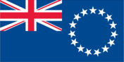
Flag
description: a blue field featuring an orange stripe and a white stripe extending diagonally from the lower-left to the upper-right corner; situated above the two stripes on the left side is a white star, characterized by four prominent rays and 20 smaller rays
meaning: blue represents the Pacific Ocean, orange signifies the Ralik Chain (or denotes sunset and courage), and white symbolizes the Ratak Chain (or indicates sunrise and peace); the star reflects the Christian cross, with each small ray corresponding to an electoral district and a larger ray representing the main cultural hubs of Majuro, Jaluit, Wotje, and Ebeye; the diagonal stripes may also be interpreted as symbolizing the equator, with the star indicating the archipelago's geographical position
Capital
name
Majuro
etymology
Majuro means "two openings" or "two eyes" and refers to the two major passages through the atoll into the Majuro lagoon
time difference
UTC+12 (17 hours ahead of Washington, DC, during Standard Time)
geographic coordinates
7 06 N, 171 23 E
Suffrage
18 years of age; universal
Citizenship
citizenship by birth
no
citizenship by descent only
at least one parent must be a citizen of the Marshall Islands
dual citizenship recognized
no
residency requirement for naturalization
5 years
Constitution
history
effective 1 May 1979
amendment process
proposed either by the National Parliament or through a constitutional convention; for Parliament to pass an amendment, a minimum of two-thirds majority vote from the total membership is required in each of two readings, followed by majority approval in a referendum; amendments proposed by a constitutional convention must receive at least two-thirds approval in a referendum
Country name
former
Trust Territory of the Pacific Islands, Marshall Islands District
etymology
named in honor of British Captain John MARSHALL, who mapped numerous islands in 1788
abbreviation
RMI
local long form
Republic of the Marshall Islands
local short form
Marshall Islands
conventional long form
Republic of the Marshall Islands
conventional short form
Marshall Islands
Independence
21 October 1986 (from the US-administered UN trusteeship)
Legal system
a hybrid legal system incorporating US and English common law, customary laws, and local regulations
Government type
a mixed governmental system that combines presidential and parliamentary elements, in free association with the US
Judicial branch
highest court(s)
Supreme Court (consists of the chief justice and 2 associate justices)
subordinate courts
High Court; District Courts; Traditional Rights Court; Community Courts
judge selection and term of office
judges are appointed by the Cabinet based on recommendations from the Judicial Service Commission (which includes the chief justice of the High Court, the attorney general, and a civilian selected by the Cabinet) and require the approval of the Nitijela; the current chief justice, who was appointed in 2013, has a term of 10 years; justices who are Marshallese citizens serve until they reach the retirement age of 72
Executive branch
cabinet
the Cabinet is selected by the president from members of the Nitijela and is appointed by the speaker of the Nitijela
chief of state
President Hilda C. HEINE (since 3 January 2023)
election results
2023: Hilda C. HEINE was elected president; National Parliament vote - Hilda C. HEINE (independent) 17, David KABUA (independent) 16
2020: David KABUA was elected president; National Parliament vote - David KABUA (independent) 20, Hilda C. HEINE (independent) 12
head of government
President Hilda C. HEINE (since 3 January 2023)
most recent election date
2 January 2023
election/appointment process
president indirectly elected by the Nitijela from among its members for a 4-year term (no term limits)
expected date of next election
2027
National holiday
Constitution Day, 1 May (1979)
National color(s)
blue, white, orange
National heritage
total World Heritage Sites
1 (cultural)
selected World Heritage Site locales
Bikini Atoll Nuclear Test Site
Political parties
historically, there have been no formally structured political parties; rather, what has been observed resembles factions or interest groups, lacking party headquarters, formal platforms, or established party structures
Legislative branch
term in office
4 years
number of seats
33 (all directly elected)
electoral system
plurality/majority
legislature name
Parliament (Nitijela)
scope of elections
full renewal
legislative structure
unicameral
most recent election date
11/20/2023
expected date of next election
November 2027
percentage of women in chamber
12.1%
National anthem(s)
title
"Forever Marshall Islands"
history
adopted in 1981; both the lyrics and music were composed by the first president of the Marshall Islands
lyrics/music
Amata KABUA
National symbol(s)
a 24-rayed star
Administrative divisions
24 municipalities; Ailinglaplap, Ailuk, Arno, Aur, Bikini & Kili, Ebon, Enewetak & Ujelang, Jabat, Jaluit, Kwajalein, Lae, Lib, Likiep, Majuro, Maloelap, Mejit, Mili, Namorik, Namu, Rongelap, Ujae, Utrik, Wotho, Wotje
Diplomatic representation in the US
FAX
[1] (202) 232-3236
chancery
2433 Massachusetts Avenue NW, Washington, DC 20008
telephone
[1] (202) 234-5414
chief of mission
Ambassador Charles Rudolph PAUL (since 27 February 2024)
consulate(s) general
Honolulu, Springdale (AR)
email address and website
Diplomatic representation from the US
FAX
[692] 247-4012
embassy
Mejen Weto, Ocean Side, Majuro
telephone
[692] 247-4011
mailing address
4380 Majuro Place, Washington DC 20521-4380
chief of mission
Ambassador Laura M. STONE (since 12 July 2024)
email address and website
[email protected]
https://mh.usembassy.gov/
International organization participation
ACP, ADB, AOSIS, FAO, G-77, IAEA, IBRD, ICAO, ICCt, IDA, IFAD, IFC, ILO, IMF, IMO, IMSO, Interpol, IOC, IOM, ITU, OPCW, PIF, Sparteca, SPC, UN, UNCTAD, UNESCO, UNHRC, WHO
International law organization participation
accepts compulsory ICJ jurisdiction with reservations; accepts ICCt jurisdiction
Economy
Budget
revenues
$171.267 million (2020 est.)
expenditures
$159.095 million (2020 est.)
Exports
Exports 2019
$91.394 million (2019 est.)
Exports 2020
$88.042 million (2020 est.)
Exports 2021
$130.016 million (2021 est.)
Imports
Imports 2019
$129.682 million (2019 est.)
Imports 2020
$132.845 million (2020 est.)
Imports 2021
$206.025 million (2021 est.)
Industries
coconut, fish processing, tourism, handicrafts (crafted from seashells, wood, and pearls)
Public debt
Public debt 2019
41.6% of GDP (2019 est.)
Remittances
Remittances 2021
13.3% of GDP (2021 est.)
Remittances 2022
13.6% of GDP (2022 est.)
Remittances 2023
13.3% of GDP (2023 est.)
Exchange rates
the US dollar is utilized
Economic overview
an upper middle-income economy in the Pacific islands; dependent on US aid; significant public sector; production of coconut oil as a substitute for diesel fuel; an emerging offshore banking center; seller of fishing rights; reliant on imports
Exports - partners
UK 16%, Germany 13%, Denmark 10%, Ghana 9%, Cyprus 9% (2023)
Imports - partners
China 47%, Japan 15%, Germany 5%, Brazil 4%, Cyprus 4% (2023)
Real GDP per capita
Real GDP per capita 2022
$6,800 (2022 est.)
Real GDP per capita 2023
$6,800 (2023 est.)
Real GDP per capita 2024
$7,200 (2024 est.)
Real GDP growth rate
Real GDP growth rate 2022
-1.1% (2022 est.)
Real GDP growth rate 2023
-3.9% (2023 est.)
Real GDP growth rate 2024
2.8% (2024 est.)
Agricultural products
coconuts (2023)
Exports - commodities
vessels, refined oil, seafood, natural gas, machinery for stone processing (2023)
Imports - commodities
vessels, refined oil, machines for additive manufacturing, iron frameworks, crude oil (2023)
Current account balance
Current account balance 2019
$86.133 million (2019 est.)
Current account balance 2020
$90.281 million (2020 est.)
Current account balance 2021
$76.263 million (2021 est.)
Taxes and other revenues
17.2% (of GDP) (2020 est.)
GDP (official exchange rate)
$280.358 million (2024 est.)
GDP - composition, by end use
household consumption
70.7% (2023 est.)
government consumption
53.5% (2023 est.)
investment in inventories
-0.5% (2023 est.)
investment in fixed capital
20.2% (2023 est.)
exports of goods and services
38.9% (2023 est.)
imports of goods and services
-71.2% (2023 est.)
Population below poverty line
7.2% (2019 est.)
Inflation rate (consumer prices)
Inflation rate (consumer prices) 2020
-0.7% (2020 est.)
Inflation rate (consumer prices) 2021
2.6% (2021 est.)
Inflation rate (consumer prices) 2022
6.2% (2022 est.)
Industrial production growth rate
-2.8% (2023 est.)
Real GDP (purchasing power parity)
Real GDP (purchasing power parity) 2022
$274.3 million (2022 est.)
Real GDP (purchasing power parity) 2023
$263.507 million (2023 est.)
Real GDP (purchasing power parity) 2024
$270.809 million (2024 est.)
GDP - composition, by sector of origin
industry
11.1% (2023 est.)
services
70.5% (2023 est.)
agriculture
19.5% (2023 est.)
Household income or consumption by percentage share
lowest 10%
2.8% (2019 est.)
highest 10%
27.5% (2019 est.)
Gini Index coefficient - distribution of family income
Gini Index coefficient - distribution of family income 2019
35.5 (2019 est.)
Energy
Electricity access
electrification - rural areas
100%
electrification - urban areas
96.1%
electrification - total population
100% (2022 est.)
Communications
Internet users
percent of population
66% (2023 est.)
Broadcast media
There is no television broadcasting station; however, a cable network operates in Majuro, offering programming through videotape playback and satellite transmissions. Additionally, there are four radio broadcasting stations; the US Armed Forces Radio and Television Service (AFRTS) delivers satellite radio and television services to Kwajalein Atoll (2019)
Internet country code
.mh
Telephones - fixed lines
total subscriptions
2,000 (2014 est.)
subscriptions per 100 inhabitants
5 (2022 est.)
Telephones - mobile cellular
total subscriptions
16,000 (2021 est.)
subscriptions per 100 inhabitants
38 (2021 est.)
Broadband - fixed subscriptions
total
1,000 (2022 est.)
subscriptions per 100 inhabitants
2 (2022 est.)
Transportation
Ports
large
0
small
0
medium
0
key ports
Enitwetak Island, Kwajalein, Majuro Atoll
very small
3
total ports
3 (2024)
ports with oil terminals
2
Airports
33 (2025)
Merchant marine
total
4,180 (2023)
by type
bulk carrier 1,939; container ship 277; general cargo 66; oil tanker 1,039; other 859
Civil aircraft registration country code prefix
V7
Military & Security
Military - note
The responsibility for defense lies with the United States; in 1982, the Marshall Islands entered into a Compact of Free Association (COFA) with the United States, which provided the Marshall Islands with financial aid and access to a variety of US domestic programs in return for exclusive military access and defense obligations by the US; this agreement took effect in 1986; additionally, the Marshall Islands is home to a US Army missile testing facility.
The Marshall Islands has established a "shiprider" agreement with the United States, permitting local maritime law enforcement officials to board US Coast Guard (USCG) and US Navy (USN) vessels, which includes the authority to board and inspect ships suspected of breaching laws or regulations within its designated exclusive economic zone (EEZ) or on the high seas; these "shiprider" agreements also allow USCG personnel and USN vessels, with USCG law enforcement officers onboard, to collaborate with host nations in safeguarding vital regional resources (2025).
Military and security forces
Marshall Islands Police Department (incorporates a Sea Patrol Division)
Transnational Issues
Refugees and internally displaced persons
IDPs
35 (2024 est.)